Llyn Dywarchen
| Alternative name | Llyn y Dywarchen [GAT SMR: 20651] | ||||||||||||||||||||||||||||||||
|---|---|---|---|---|---|---|---|---|---|---|---|---|---|---|---|---|---|---|---|---|---|---|---|---|---|---|---|---|---|---|---|---|---|
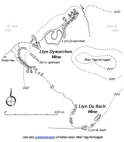
| Location | SH654346 (Area map showing location.) | ||||||||||||||||||||||||||||||||
| Parish | Talsarnau | ||||||||||||||||||||||||||||||||
| Geology | The main outcrop comences about 245 m south of Llyn Dwarchen at an altitude of about 488 m and after curving round the end of a ridge runs along it in a south-easterly direction; the dip being to the north-west. The outcrop gradually rises towards Llyn Du where it reaches a height of 549 m. Throughout this distance of 800 m the bed has a maximum thickness of .45 m but is rarely more than .3 m thick. A fault running north-west to south-east with the downthrow to the north east separates a further outcrop to the north-east of Llyn Dywarchen. [Dewey & Bromehead 1915: 52] | ||||||||||||||||||||||||||||||||
| Owners | Welsh Manganese Co. Ltd / Ellis Pritchard 1892 Ellis Pritchard 1893–1897 |
||||||||||||||||||||||||||||||||
| Production and Employment |
|
||||||||||||||||||||||||||||||||
| Transport | Cart track to Eisingrug. It has been suggested that during the First World War a motor lorry made a daily journey (taking the whole day for the round trip) from Talsarnau station to Llyn Du Bach and/or this mine in their last days of working [Ruston 2000]. Dewey & Bromehead [1915: 53] consider that the steep descent from the workings to Llyn Eiddew Bach would have necessitated sledges or pack horses for this section of the journey. | ||||||||||||||||||||||||||||||||
| Remains | Opencast workings cut into face of outcrop and parts now buried by fallen undercut boulders. Mine track along face of steep slope apparently built on tipped waste. Loading bank and bridge abutments for tramway across track to tip at SH65303484. Two small shelters (both roofless) partly built into tip near SH65533500. All remains adjacent to track. (December 2003) | ||||||||||||||||||||||||||||||||
In 1915 the mine was described as “abandoned”. [Dewey & Bromehead 1915: 52], however, in 1923 it was described as “active” [Dewey & Dines 1923: 64].