Hafotty
| Alternative names |
Barmouth Dyffryn Hafodty Mafotty? [Down 1980: 67] Llanaber? |
||||||||||||||||||||||||||||||||||||||||||||||||
|---|---|---|---|---|---|---|---|---|---|---|---|---|---|---|---|---|---|---|---|---|---|---|---|---|---|---|---|---|---|---|---|---|---|---|---|---|---|---|---|---|---|---|---|---|---|---|---|---|---|
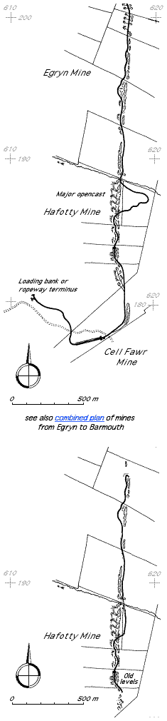
| Location | SH618198 (northernmost extent of working before 1900?) – SH615177 (approximate boundary with Cell Fawr mine). (Area map showing location.) | ||||||||||||||||||||||||||||||||||||||||||||||||
| Parish | Llanaber | ||||||||||||||||||||||||||||||||||||||||||||||||
| Geology | The ore bed is about .25 m thick, is interbedded with Harlech grits and imediately underlain by a 50mm bed of shaly sandstone containing numerous large cubes of iron pyrites. The whole series dips east at about 70°. The ore consists mostly of carbonate of manganese with hydrated black oxide coating it where exposed to the weather. Associated with the ore are many veins of quartz which sometimes contain copper pyrites. Large botryoidal lumps of manganese also occur. [Dewey & Bromehead 1915: 51] | ||||||||||||||||||||||||||||||||||||||||||||||||
| Owners |
|
||||||||||||||||||||||||||||||||||||||||||||||||
| Production and Employment |
|
||||||||||||||||||||||||||||||||||||||||||||||||
| Transport | Within the mine there was a 2' gauge tramway along the workings with short inclines, at least one of which was balanced. Output was by incline (non-balanced) and tramway to loading point at SH611180. Railway was 24" gauge, bridge or 5lb flat-bottom rail, on wood sleepers at 36" intervals [Boyd 1970: 289]. (The rail weight of 5lb given by Boyd seems unusually light [David Black 2002, pers. comm.]. The lightest rail encountered in other sources is 9lb/yd [Link 1979: 14]) From the loading point the ore was taken by horse-drawn sledge to the Barmouth road near Llanaber church (SH59941806) and from there by horse and cart to Barmouth station [Williams 2006]. | ||||||||||||||||||||||||||||||||||||||||||||||||
| Remains | A series of depressions and grassed-over waste tips, continuing northwards as Egryn mine and southwards as Cell Fawr mine. There are a number of openings into the steeply-dipping deep worked bed at SH616183. There are remains of the internal tramway formation including a bridge over the workings at SH616186, an incline and possible sheave pit, the exit incline and exit tramway formation and the loading point. There is a short piece of light flat-bottom rail by the northernmost opening to the underground workings. There is a smithy (roofless) at SH71712362. There are remains of two buildings at SH61771885, an isolated building at SH61701804 (magazine?) and two buildings at SH61681780. There is a low, semi-circular wall, posibly a dam, close to the line of the tramway to the top of the incline at SH61641784 (this may be agricultural and not connected with the mine). (January 2004) | ||||||||||||||||||||||||||||||||||||||||||||||||
| Access | With the exception of openings to the deep workings, most remains are close to, and accessible from, Public Rights of Way. | ||||||||||||||||||||||||||||||||||||||||||||||||
The largest mine in Merioneth on the basis of recorded output. Started in December 1885. The 1887 1" OS map (Sheet 135 Harlech surveyed 1887, published 1892) shows a short length of working SH61711866–SH61731887 as “Hafotty Mines” with a possible indication of a short length of tramway on the line of the mine immediately south of the working.
The bed dipped steeply (~ 70°) and there were both surface (opencast) and underground workings. The underground workings were stopes worked on several levels with near-horizontal timber stemples [Halse 1887: 110]. Halse comments that the method of working seemed to be intended to win the ore as quickly as possible. The 1887 6" map [OS 1st edn: XXXVI NW] shows a level at SH616178. The orientation of the cutting at this point suggests that it might have connected with these workings.
From the loading point there was a track. Cartage costs on this track were 3s (15p) per ton. (For ore that was worth about 30s (£1.50) per ton f.o.b. at Barmouth.) [Halse 1887: 110].
According to Down, the loading point was later served by an aerial ropeway and that from the bottom of the ropeway there was cartage to Barmouth station. However, Halse [1887: 110]) says only that there was a plan for a “wire tramway” (a contemporary term for an aerial ropeway) to Barmouth. There is no indication of this ropeway on the 1900 revision of the 6" map [OS 2nd edn: XXXVI NW] or on the ground and it is probable it was never built. This map does show the route of the incline, tramway formation to the loading point and the loading bank, but no track is shown on them. (The tramway is shown here on the 1st edition but presumably it had been lifted before 1900.) It is probable that the tramway shown on Down’s plan [1980: 44] (right) never existed in its entirety at any one time.
In August 1894, by order of the Sheriff of Merioneth, there was to be a sale by auction at Pensarn of about 500 tons of manganese ore lying at the station ready for trucking and afterwards, at the mine, of 2 miles of iron rails, 400 yards wire rope, 250 yards chain, 2 winding drums, 2 horizontal winding wheels, 1 small water wheel, 27 tramway Trucks, miscellaneous mining tools etc. and about 10 tons of manganese ore [Cambrian News 17/8/1894 p. 1].
The 6" map revision of 1900 [OS 2nd edn: XXXII SW] (used as the basis for the plan lower right) marks the mines as “Disused” and shows the tramway running from SH618198 (where a very tight half-circle of track is shown) to SH617182 (which is at the top of the incline shown in the photograph below). The line of this tramway does not follow that shown by Down on the plan (above right) between SH617188 and SH617186 where the tramway is shown looping away from the mines to the east. On the map this loop is shown as a track and the tramway follows a more direct north-south line just to the east of the wall that runs parallel to the mine. (There is no sign of tramway formation on the ground to support this line.) The northern terminus of the tramway at SH618198 might indicate that Hafotty extended further to the north than the legend “Egryn Mine” on Down’s plan suggests. The map also shows a track (i.e. shown as a doubled dotted line, not the single dotted line of a path) running south-west from SH617186 along the route of the present pedestrian Right of Way.
In 1907 two men were employed making surface trials for manganese. W Bowen-Jones writes:
The bed of ore is heavily covered by [omitted] & manganese has only been discovered in one spot and a quantity raised. Walked through this sett and found two dangerous openings at the north end. Nothing done in mining and could not find out that any sample loads of ore had been taken away as stated by Hills in his letter to O.W. [GAS CAO: XD/35/420 pp. 154–155](This notebook entry is headed “North Hafodty Adamson IN” – possibly this is Edmund Adamson. “Hills” was presumably W A Hills and “O.W.” may have been Thomas O Williams.)
In 1916 thirteen men were employed for at least three months making surface cuttings in three places to expose the manganese bed which was covered by drift to a depth of 3 or 4 yards (2.7–3.7m). The quality of the ore was described as “ordinary” and it was noted that the depth of drift hampered the workings and mining would be costly. [GAS CAO: XD/35/424 p. 107] (Dewey & Bromehead [1915: 51] reporting on Hafotty and Cell Fechan about this time describe the mines as “abandoned” with the levels flooded and overgrown but with a good deal of ore remaining.)
Further working may have occurred up to c.1924 as part of the Egryn mine operations of that period with output being taken via the Egryn tramway and aerial ropeway [Down 1980: 45].
Williams [2003] says there were remains of tramway track, rope and wooden headgear on the incline in the 1950s. He was told by Robin Lewis that he (Lewis) used to work in the mines in the 1920s and bring ore down to the road at Llanaber church on a cart and attached sledge, usually three loads per day. The sledge was loaded on the cart for the return uphill journey which required two horses. Lewis also told Williams that miners used to live at the mine during the week, sleeping in the buildings near the top of the incline.
There is a suggestion that the terrace of houses named Pen-rhiw (SH59961804) was built (possibly towards the end of the nineteenth century) for manganese miners. [Cope 2012]
 Photograph © Crown Copyright: RCAHMW |
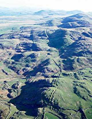
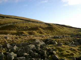
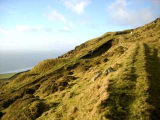
Workings
Aerial view looking north. The remains of the workings is the clearly visible line of trenches running up the centre of the picture. In the foreground (from bottom to aproximately centre of picture) are Cell Fawr workings. Hafotty continues northwards from these and in the distance beyond Hafotty can be seen the Egryn workings. The Hafotty exit incline started from approximately the centre of the picture and decends westwards (towards the left of the picture) to continue generally northwards as a gently descending tramway. |
|
 |
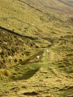
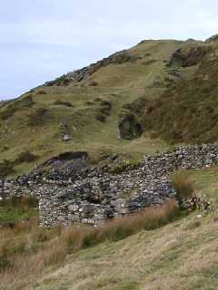
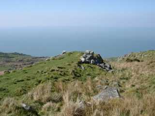
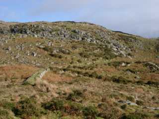
Workings
Looking north from SH616186 across Llywn-du parc. The dark hill in the background is Moelfre, Moelfre and Hendre mines are on the far side of it. |
|
 |
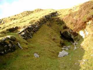
Bridge over workings
This bridge carried the tramway across the workings. see also other side of bridge |
|
 |
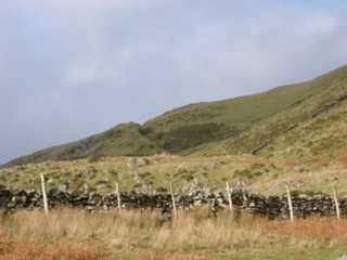
Tips
Some of the many tips on the downhill (west) side of the workings. |
|
 |
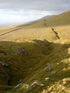
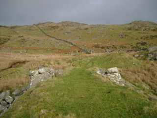
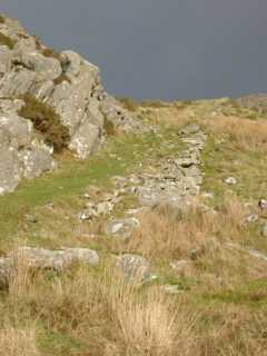
Incline
Looking down the incline that served this part of the mine. There is a possible sheave pit immediately behind the viewpoint. The workings are to the left of the incline. The tramway that ran the length of the workings appears to have taken a less steep route initially out of sight off the left of this picture. Its route can be seen running from left to right into the distance across the top of the picture. |
|
 |
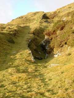
Incline and underground working
Showing the construction of the upper part of the incline and one of the openings to the underground workings. The workings consist of a stope which is 10 m (estimated) deep and perhaps 15 m long. The stope has not been descended because of the loose material around the pitch head and concern about the state of the roof above the stope. |
|
 |
Incline and underground working
The working level below that in the previous picture. The dark area conceals a large (~ 3 m x 1m) opening into the worked out bed, which dips at ~ 70°. This stope has been descended to about 10 m depth but is choked in both directions with loose material. The stope is floored with mainly loose material and there is a hole in the floor through boulders into (possibly deep) water. |
|
 |
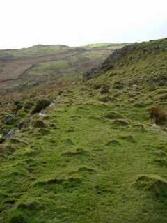
Incline
Note the slope of the incline and the tips to the left of it. The track in the foreground is thought to be the main line of the mine tramway, at this point taking a less steep route across the slope. |
|
 |
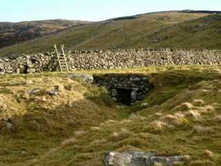
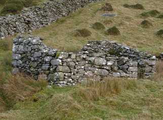
Smithy
Smithy at SH71712362. Internal dimensions are aproximately 2.5 m x 4 m. There are two windows (partialy blocked and not easily visible in the photograph) and a doorway in the in the long wall and a niche (again not visible in the photograph) in the wall opposite the central window. Beyond the smithy can be seen the incline and tips visible in the previous photo. |
|
 |
Smithy
Another view of the smithy at SH71712362. There are slight similarities to the smithy at Hendre. |
|
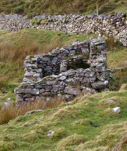 |
Smithy
A further view showing some interior detail. The hearth is the far right hand corner and the bellows would have been in the far left corner. The chimney would have been in the far right hand corner but there are no signifiicant remains and its construction is not clear. |
|
 |
Incline and workings
The incline and workings as above seen from SH617177. |
|
 |
Head of exit incline The head of the exit incline of the mine. The lower photograph shows the head of the incline looking back towards the previous viewpoint from the top of the incline slope and shows detail of stonework. There is no clear indication as to the nature of the winding or brake gear. There does not seem to be sufficient remaining stonework in the vicinity to suggest an over-incline drum house, and there is no suggestion of an under-track wheel pit. It is possible that there was an over-track sheave or drum supported by a wooden framework erected on the abutments. Williams [2003] says there were remains of track, rope and wooden headgear on the incline in the 1950s. Imediately beyond the right hand abutment is a waste tip. Its ‘finger’ shape suggests there was a tramway on it. In the distance beyond the right-hand abutment can be seen a small ruined stone structure which is close to the cutting that carried the tramway from the level marked on the 6" map [OS 1st edn: XXXVI NW] at SH617178 to the head of the incline. Its function is unclear although it may have been a checker’s shelter. (There is no sign of a pit for a weighbridge.) There are remains of a larger building close by (not visible in photograph). The cutting usually carries a small stream which rises in its bed and which may be drainage from the mine. |
|
 |
||
 |
Exit Incline
Looking down the exit incline from the same location as the previous photograph. |
|
 |
Exit Incline
Looking up the exit incline. |
|
 |
Exit tramway
Tramway formation on causeway part-way between foot of exit incline and the loading bank. |
|
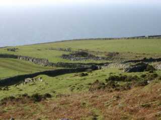 |
Loading bank
The track possibly divided at this point with the left branch going to the loading bank and the right branch possibly running onto the masonry structure seen to the right of the photograph. |
|
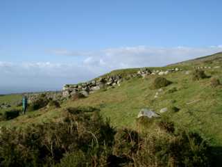 |
Loading bank
A view to show the size and masonry construction of the loading bank. Note figure on the left for scale. |