Cell Fawr
| Alternative name | Cel Fawr | ||||||||||||||||
|---|---|---|---|---|---|---|---|---|---|---|---|---|---|---|---|---|---|
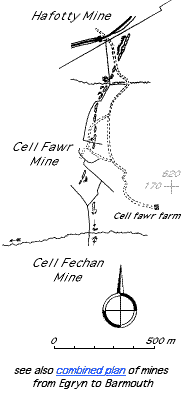
| Location | SH615177 (approximate boundary with Hafotty mine) – SH615168 (approximate boundary with Cell Fechan mine). (Area map showing location.) | ||||||||||||||||
| Parish | Llanaber | ||||||||||||||||
| Owners | 1891–1894 Dyffryn Mining Co. Ltd | ||||||||||||||||
| Agents |
|
||||||||||||||||
| Production and Employment |
|
||||||||||||||||
| Transport | There was a tramway connection from the levels to the head of the Hafotty incline. [OS 6" Merionethshire sheet XXXVI.NW Surveyed: 1887, Published: 1888 map.] | ||||||||||||||||
| Remains | An intermittent series of shallow depressions and grassed-over waste tips, continuing northwards as Hafotty mine and southwards as Cell Fechan mine. Small underground working approximately 2 m x 4 m at SH616172 with pack walls and wooden props. Worked out chamber at SH615169. (March 2002) | ||||||||||||||||
| Access | Most remains are close to, and accessible from, Public Rights of Way. | ||||||||||||||||
 Working was probably limited by the poor access to this part of the outcrop and the instability of the company [Down 1980: 43].
 Photograph © Crown Copyright: RCAHMW |
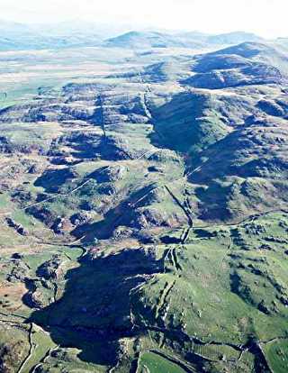
Workings
Aerial view looking north. The remains of the workings are the clearly visible trenches running up the centre of the picture. In the foreground (from bottom to aproximately centre of picture) are the Cell Fawr workings. Hafotty continues northwards from these and in the distance beyond can be seen the Egryn workings. |
|
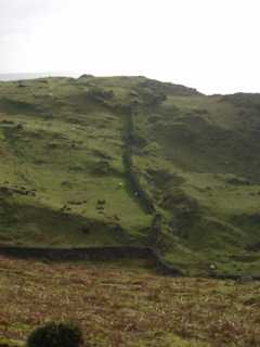 |
Workings
Looking south from SH616186 across part of Cell Fawr workings. Note tips to right of workings and on skyline. |