Foel Wen
| Alternative name | Voelwen | ||||||||||||||||||||||||
|---|---|---|---|---|---|---|---|---|---|---|---|---|---|---|---|---|---|---|---|---|---|---|---|---|---|
| Location | SH631270 (Area map showing location.) | ||||||||||||||||||||||||
| Parish | Llanbedr | ||||||||||||||||||||||||
| Owners |
|
||||||||||||||||||||||||
| Worked | 1835–1840 (? see History), 1889–1892, 1918 | ||||||||||||||||||||||||
| Production and Employment |
|
||||||||||||||||||||||||
| Transport | Tramway with exit incline to intermediate tramway leading to a second incline to a loading bank near Gareg Lwyd SH62552722. (Gauge 24"? [Boyd 1970: 289]) | ||||||||||||||||||||||||
| Remains | Mostly opencast workings, although there are some underground workings, one of which has a central wall of stacked deads. The tramway and incline formations are visible. The upper incline has a widening at approximately its mid-point, possibly for a passing loop. The intermediate tramway formation is on a very narrow drystone causeway in part. Both the upper and lower inclines have banks across them part-way down giving them an unfinished look. The loading bank at the bottom of the lower incline at SH62552722 has two levels, the lower one being possibly for stacking ore between unloading from incline trucks and loading into cart wagons. Smithy (dilapidated and roofless) at SH63102716 and possible shelter at SH63152728. (October 2003) | ||||||||||||||||||||||||
| Access | With the exception of the inclines and intermediate tramway, most remains are close to, and accessible from, a Public Right of Way. | ||||||||||||||||||||||||
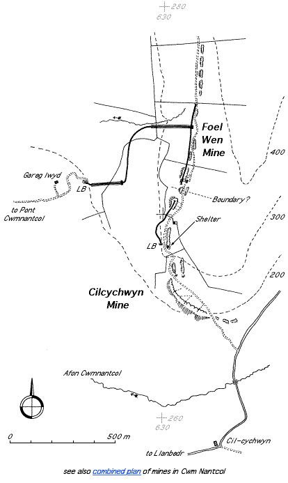
The tramway system is not shown on the 1887 or 1900 6" maps [OS 1st edn: XXVI SE] and [OS 2nd edn: XXVI SE].
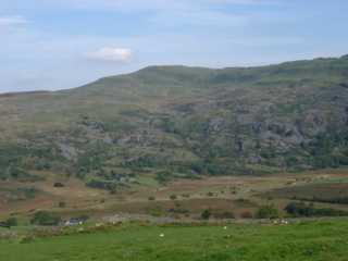 |
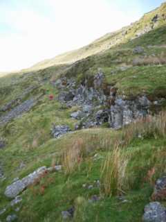
General view of mine
Looking north from SH615259 (near Moelfre mine). The workings run more or less horizontally across the hillside from the centre of the picture to the right above the grey rocky outcrops. |
|
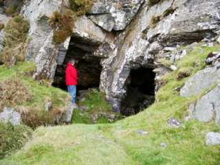 |
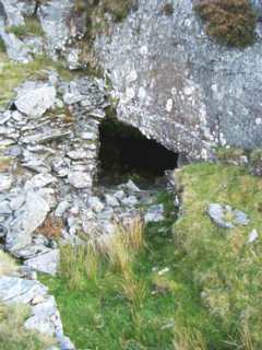
Entrance to underground workings
The opening on the left (behind the standing figure) has been cut through solid rock whilst the right hand wall of the right hand entrance is composed of stacked waste. |
|
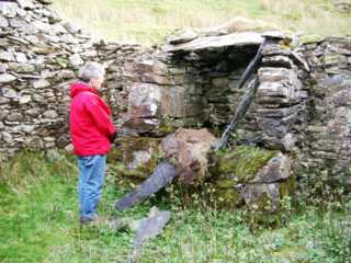 |
Smithy hearth
Hearth in smithy at SH63102716. The doorway to the smithy faces north and is immediately behind the camera position. In the west-facing wall (out of sight to the right of the picture) is a large, walled-up window aperture with the remains of a wooden window sill. |
|
 |
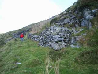
Tramway formation serving workings
Looking north along line of tramway that served the workings from near SH631272. Note stacks of walled-up waste. The entrances to the underground workings are between the stacks of waste. |
|
 |
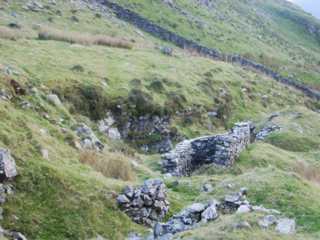
Entrance to underground workings
Entrance to underground workings formed by walling up surface workings with waste. |
|
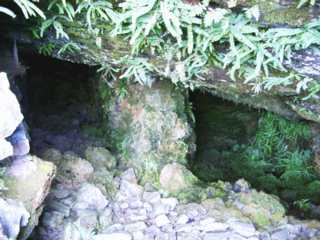 |
Underground working
Just inside the entrance shown in the previous picture. Note pillar of rock left to support the roof. |
|
 |
Waste stack
It is obvious that significant effort has gone into the stacking of waste in this fashion. Possible reasons might be a requirement in the lease to occupy as little ground as possible or else it was less costly to stack waste in this manner than to carry it to a point at which it could be dumped down-slope of the workings. |
|
 |
Shelter
Shelter or possibly stable built in surface workings at SH63152728. The building appears to have had a single-pitched roof and to have been open at the north end (facing the camera). There is no sign of a hearth or chimney. |
|
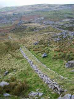 |
Top incline
Looking down the top incline. Although the two sections of incline are aligned in plan, the gradient profile is discontinuous. It is not clear if the incline was ever completed. The brow that interrupts the incline does not show any sign of incline formation on it, but appears too soft to have had rails laid directly on it. There are no indications of head-gear above the incline. From the bottom of this incline a narrow and very lightly constructed drystone causeway suggests the course of a tramway to the top of the bottom incline. |
|
 |
Bottom incline
Looking up at the bottom incline from by near loading bank at SH62552722. The course of the incline is interrupted by a brow. It is not clear if this brow is the result of ground movement since the incline was in use or if the incline was never completed. |