Barmouth
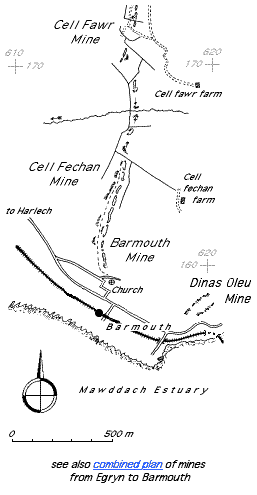
| Location | SH613167 (Area map showing location.) | ||||||||||||||||||||||||||||||||
|---|---|---|---|---|---|---|---|---|---|---|---|---|---|---|---|---|---|---|---|---|---|---|---|---|---|---|---|---|---|---|---|---|---|
| Parish | Llanaber | ||||||||||||||||||||||||||||||||
| Owner | John Abraham 1886–1892 | ||||||||||||||||||||||||||||||||
| Production and Employment |
|
||||||||||||||||||||||||||||||||
| Transport | There is a track, cut into the hillside or on masonry embankments with bridges over gullies, which appears to have served the mine. Down [1980: 43] suggests this may have been a tramway. | ||||||||||||||||||||||||||||||||
| Remains | A number of underground workings with pack walls (and, in one case, a wooden prop) and a series of shallow depressions and grassed-over waste tips, running northwards up the hill and continuing northwards as Cell Fechan mine. (March 2002) | ||||||||||||||||||||||||||||||||
| Access | The path from Barmouth town to Craig y Gigfran (more generally known in Barmouth as ‘The Crag’) runs alongside the workings. | ||||||||||||||||||||||||||||||||
It was reported by the son of the mine foreman that there was a letter from the “owner in Birmingham” (presumably John Abraham) to the mine foreman complaining of falling output, to which the foreman replied that it was the result of an influenza epidemic in Barmouth [Giffin 2002].
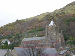 |
St John’s church, Barmouth This photograph and the following two photographs are included because of their proximity to the managanese workings. |
|
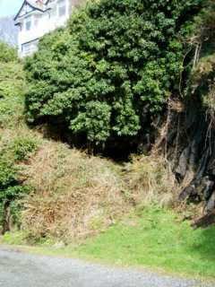 |
Entrance to trial in St John’s churchyard The entrance is in the deep shadow beneath the tree. The white house is the one visible to the left of the church in the picture above. The trial follows a quartz vein. A chamber slopes uphill from the entrance. A way on can be seen over fallen boulders. |
|
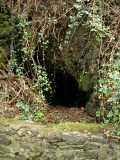 |
Dripping Well Trial
Entrance by track off Ffordd Gellfechan at SH613160. A trial for copper for and lead on the same thick quartz vein as the previously mentioned trial in the church yard lower down the hill [Allen & Jackson 1985a: 16]. It is approximately 5 m long. (There are three other similar trials higher up the hill adjacent to the track from Barmouth to Cell Fechan farm: although marked as “Old Level (Manganese)” and “Levels (Manganese)” on the 1900 25" map [OS 2nd edn: XXXVI.6], these trials are more likely to have been attempts to find the south-westerly ends of the Panorama mine lodes or be assoicated with the Belle Vue gold mine, the location of which is given by Wilkinson [2003: 15044] as SH613161.) The low wall in front of the entrance (the top of which is visible in the foreground) appears to be a dam to provide a water supply. Locally known as ‘The Wishing Well’ [Speak 2002] or ‘The Dripping Well’. |
|
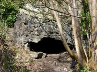 |
Entrance to workings
Entrance in quarried bay by track off Ffordd Gellfechan at SH613160 approximately 13 m to north of above trial. Note contact between beds in strata above the entrance. This entrance leads to a series of chambers that run uphill from the entrance. They contain some walling. |
|
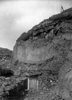 Photograph © British Geological Survey (catalogue reference P248126) |
The above entrance as it was in 1894. (The location has been verified by on-site examination of the distinctive strata above the entrance.) It is not known whether the door was used to secure the workings or if it was a later construction to convert the workings into a store. |
|
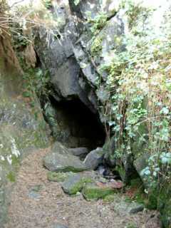 |
Entrance to workings
Entrance at SH613160. This entrance leads to a linear working, initially on the strike, which at its end leads uphill to a small exit in a small bay. There are deads stacked in the roof, in one case they form a precarious-looking arch. |