Rhinog
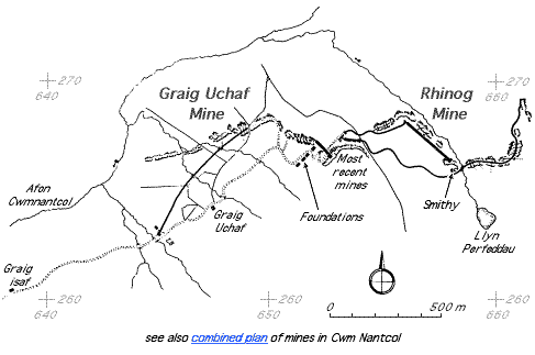
| Location | SH654267 (Area map showing location.) | ||||||||||||||||||||||||||||||||
|---|---|---|---|---|---|---|---|---|---|---|---|---|---|---|---|---|---|---|---|---|---|---|---|---|---|---|---|---|---|---|---|---|---|
| Parish | Llanbedr | ||||||||||||||||||||||||||||||||
| Owners |
| ||||||||||||||||||||||||||||||||
| Production and Employment |
|
||||||||||||||||||||||||||||||||
| Transport | Possibly barrow on level section above incline [Gwyn 1998: app. 2: 151]. Railway, 1.2km, with two inclines, one balanced, and aerial ropeway. Railway construction 24" gauge, bridge rail on wood sleepers at 36" intervals or 5lb flat-bottom rail on Hudson metal sleepers. Tub wagons with 9" diameter wheels. Two ropeways [Boyd 1970: 289, 291], one of which took ore to the ore bin on the track. During the last re-working of the mine a motor lorry was used to take ore from a bin on the track to the GWR at Llanbedr [Dewey & Dines 1923: 68]. | ||||||||||||||||||||||||||||||||
| Remains | Workings cover a considerable area, much overgrown with heather. Series of small adits at lower end of outcrop. Loading banks. Tramway formations. Further up the hill is a large tip confined by a retaining wall and substantial masonry piers, possibly tower footings for an aerial ropeway, terminating an extensive run of old opencast and underground workings. Down [1980: 41] reports some tramway remains including steel and wooden sleepers. Smithy with hearth and second room with separate entrance, identified as a stable by Boyd [1970: 291], at SH65582667. Ore bin or storage platform and loading bank at foot of incline SH65252675. Foundations for four wooden buildings SH65092655–SH65252665, 16 m x 6 m, built into slope. One building shows evidence of cross walls, the others have a median division with possible hearth or stove base in middle and attached outside flush W.C.s suggesting they were barracks. There is a foundation for machinery or possibly ropeway equipment at SH65082676. (February 2007) | ||||||||||||||||||||||||||||||||
In 1916 twenty-four men were employed and considerable work had been done to make road and inclines. Compressed air plant was installed “near the outcrop” [Dewey & Dines 1923: 68]. The working was mostly on the surface with the bed being described as very contorted. A quantity of ore was removed. [GAS CAO: XD/35/424 p. 129] This diary entry is headed “Graig Uchaf”, however, the description of the mine indicates that the entry refers to Rhinog.
In 1917 twenty-two men were employed. The workings continued to be mostly surface cuttings and excavations. The workings were being extended further up the mountain and the exposure of the situation to winter weather and the conseqential increase of the cost of production was noted. The quality of the ore was described as being maintained and well oxidized for a good depth under the surface. [GAS CAO: XD/35/424 p. 160]
The tramway is shown on the 1918 1" map [OS 1918: 116] running west from SH658268 to the end of the cart track at SH652268.
The mine was described as “active” in 1923. [Dewey & Dines 1923: 68]
The location was also recorded as a gold mine owned by H J Wright in 1896. A five-yard trial was made and a prospectus was issued for this in 1885 by The Welsh Gold Prospecting and Development Syndicate Ltd of which Wright was one of the directors. [FRO: D/DM/448/84]
Note that Boyd [1970: 289, 291] refers to his description and plan of Rhinog mine as “Graig Uchaf”. The rail weight of 5lb given by him (see Transport above) seems unusually light [David Black 2002, pers. comm.]. The lightest rail encountered in other sources is 9lb/yd [Link 1979: 14]
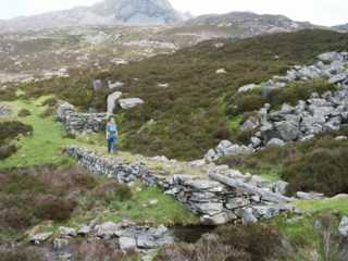 |
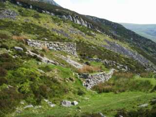
Causeway and bridge abutment
Causeway, presumably for tramway, leading to bridge at SH65622678. Behind the figure on the causeway can be seen the remains of a shelter or, in view of its closeness to and alignment with the presumed tramway, a checker’s office. (There is no sign of a weighbridge pit.) There is a series of adits on the right of the incline leading up the hill. |
|
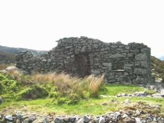 |
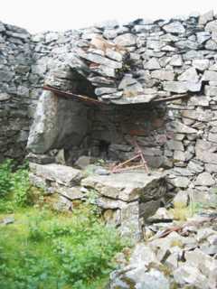
Smithy and stable
Smithy and stable at SH65582667. The smithy has a door and window on the east side (facing the camera). The stable has a separate entrance on the south side of the building |
|
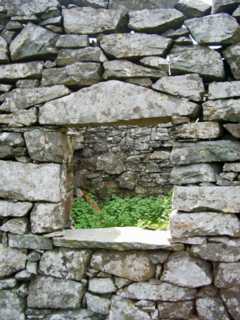 |
Smithy window detail
Note the unusual shape of the lintel. |
|
 |
Smithy hearth
Smithy hearth against north wall of building. |
|
 |
Ore bin and loading bank
Ore bin (or storage platform) and loading bank at foot of incline at SH65252675. |
|
 |
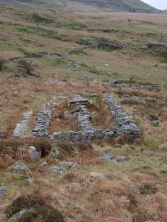
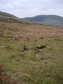
Barracks
Foundations for four (presumed) wooden barrack buildings at SH652266. (The fourth is out of sight to the left of the picture.) Part of the workings can be seen either side of the nearest building and the track from the upper part of the mine passes between that building and the next. The building nearest the viewpoint has a number of cross-walls, the other buildings have a median division, a stove foundation and an attached outside flush toilet. The uniformity of the foundation plan, the use of wood and the presence of the outside toilets suggests that these buildings may have been built sometime in the 20th century, possibly for the re-opening of the mine during World War I. One of the bulidings was later dismantled and re-erected in Harlech. [Jones 2009] |
|
 |
Barrack foundation
Note concrete stove foundation on centre stub-wall. |
|
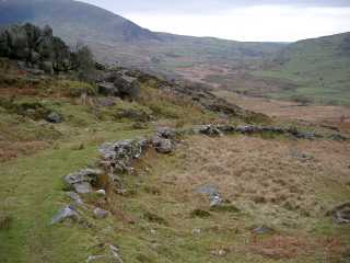 |
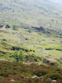
Track from mine
Track from mine leading via Graig Uchaf and Graig Isaf farms to the Cwm Nantcol road at Cil-cychwyn. |
|
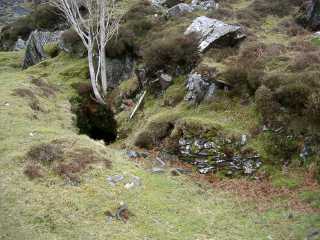 |
Entrance to underground workings
Workings below Rhinog barracks. |
|
 |
Foundation
Foundations for machinery or possibly ropeway equipment at SH65082676. The construction appears to be wooden beams set in the ground with holding-down studs. |