Coed
| Alternative names | Coed & Lletty Walter Coed Mawr [RCAHMW CARN: 33965] Harlech Lletty Llanbedr Harlech sulphur mine [GAT SMR: 21827] Harlech iron mine [Wilkinson 2003: 14284] |
Location | SH604280 (Area map showing location.) | ||||||||||||||||||||||||||||||||||||||||||||||||||||||||||||||||
|---|---|---|---|---|---|---|---|---|---|---|---|---|---|---|---|---|---|---|---|---|---|---|---|---|---|---|---|---|---|---|---|---|---|---|---|---|---|---|---|---|---|---|---|---|---|---|---|---|---|---|---|---|---|---|---|---|---|---|---|---|---|---|---|---|---|---|---|
| Parish | Llanbedr | ||||||||||||||||||||||||||||||||||||||||||||||||||||||||||||||||||
| Owners |
| ||||||||||||||||||||||||||||||||||||||||||||||||||||||||||||||||||
| Production and Employment |
2 listed as ‘Coed’ from this date 3 excludes pyrites production 1872–1875, includes output from Lletty Walter 1890 onwards |
||||||||||||||||||||||||||||||||||||||||||||||||||||||||||||||||||
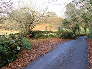
| Transport | Short tramway to loading point on Cwm Bychan road. There are indications of sleepers in one passage in the worked-out bed suggesting it had rails laid in it. | ||||||||||||||||||||||||||||||||||||||||||||||||||||||||||||||||||
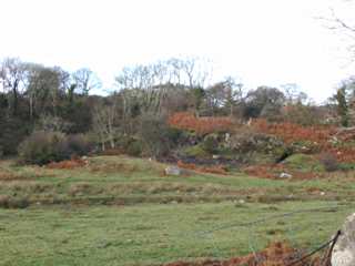
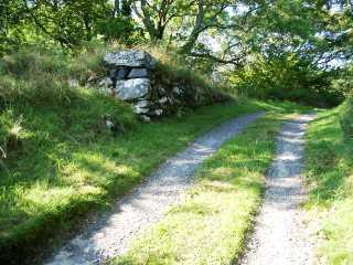
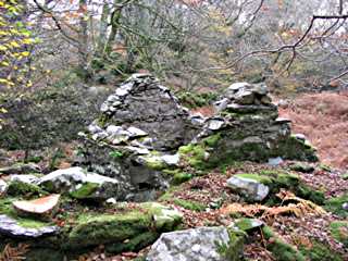
| Remains | Considerable network of underground workings which extend north of the main stoped area shown on the plan below to beyond the small stopes shown on the north side of the track. These workings have been filled with stacked waste though which a number of passages have been left, including one which follows the eastern boundary of the worked-out area. Some entrances have been blocked with or contain a considerable amount of rubbish including animal bones. There are waste tips on the surface, some of which appear to have been robbed for ballast. Roofless building at SH60422789 which may have been a magazine. Loading bank at roadside at SH60432791 and beside track at SH60392746. Drainage level to Afon Artro at SH60052795. (November 2003) Re-working of tips continues. (September 2005) | ||||||||||||||||||||||||||||||||||||||||||||||||||||||||||||||||||
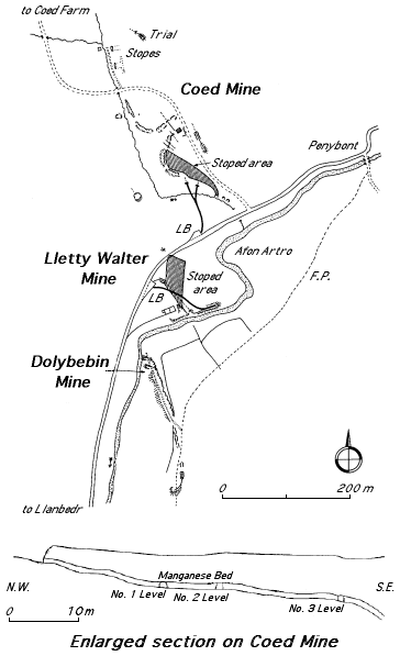
In 1869 the mine was named Harlech Lletty and listed as a manganese and lead mine, but up to 1878 it had only produced iron pyrites. ([GAT SMR: 21827] refers to Harlech Sulphur Mine at SH604280, the same grid reference as Coed and Wilkinson [2003: 14284] lists Lletty Iron Mine at the same location.) It was abandoned in 1878. The mine re-opened in 1886 and was developed on a large scale. In 1887 there were three levels sending ore to the road via a short tramway. A detailed plan (the 1887 abandonment plan for Dolbebin mine, surveyed by Edward Stables), which includes Coed, exists [GAS DAO: 2125]. The plan (right) and enlarged section (below right) are based on that plan. Manganese was produced until 1889.
In March 1887, Harlech Highway Board claimed against Henry Stringfellow Lancaster, as agent for the Dyffryn Mining Co, for £61 1s. 2d. damage alleged to have been done to the highway leading from Llety Water [sic.] to Llanbedr by “excessive weight and extraordinary traffic caused by waggons and cars containing manganese ore travelling over the road during the year ending the 25th of March, 1887” was fixed for hearing. The company was said to have carted 3243 tons 15 cwts of ore over the road between August 1886 and March 1887. [North Wales Chronicle 19/3/1887 p. 6]
In 1890 the mine was renamed Coed or ‘Llanbedr, lately Coed’, possibly indicating that all operations had moved to the Coed end of the site. It worked under this name until closure in 1891. It reopened again in 1901 and worked until 1903 producing small tonnages. The last reported working was in 1923 [Dewey & Dines 1923: 65] with levels being driven, possibly at the north end of the site. [Down 1980: 32]
See also Lletty Walter mine which was worked as part of the same operation. The output records below refer to the combined mine as “Coed & Lletty Walter” up to 1889.
This location is also tentatively identified as Harlech Sulphur mine [GAT SMR: 21827] which presumably relates to the output of pyrites shown above.
The underground workings which extend north of the main stoped area shown on the plan above (referred to in the Remains section above) have similarities to the ‘Shopshire’ longwall method of working as described by Brown [2007] at Hartley Bank Colliery in West Yorkshire.
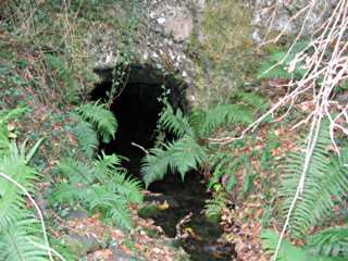
South east of the mine is a level that carries a stream from near the workings through solid rock under the Cwm Bychan road to emerge just above river level at SH60052795 (see plan above right). The water enters the end of the level from a very small cross-section rise (less than man-sized and containing a 6" diameter pipe) that appears to break though into a shaft or the lowest point of the Coed workings. It would appear that this level was driven to drain the Coed workings and/or to divert the stream away from the Lletty Walter workings. Associated with these works is a drainage ditch running eastwards to the sink-point in the field between the Coed loading bank and the workings.
The plan (above right) is incorrect in that the alignment of the Dolbebin mine workings and track that descend to the river is approximately N.N.E. - S.S.W. rather than as shown currently. A corrected plan will be shown in due course.