Cefn y Clawdd
| Alternative names | Cafn y Clawdd Cefn Clawdd |
||||||||||||||||||||||||||||
|---|---|---|---|---|---|---|---|---|---|---|---|---|---|---|---|---|---|---|---|---|---|---|---|---|---|---|---|---|---|
| Location | SH667346 (Area map showing location.) | ||||||||||||||||||||||||||||
| Parish | Trawsfynydd | Owners | 1919–1925 Edward Tudor | ||||||||||||||||||||||||||
| Worked | –1921 ? | ||||||||||||||||||||||||||||
| Production and Employment |
|
||||||||||||||||||||||||||||
| Transport | Temporary rails laid to finger tips. Ore probably carted or taken by motor vehicle to Trawsfynydd station. | ||||||||||||||||||||||||||||
| Remains | Track running full length of workings, in some places on top of stacked waste. Shallow near-continuous opencut working for aproximately .5km on north-west side of track from SH66933461 to SH66433443. Linear tips on opposite side of track to workings from SH66933461 to SH66863462 and between track and workings from SH66493448 to SH66433443. Finger tips at SH66723462, SH66553453 and SH66433443. Some pieces of bridge rail (including two pieces possibly in situ) at west end of workings. Building at SH66863459 and tiny shelter at SH66663463. The heaps of ore referred to by Down [1980: 28] were not found. (June 2005) | ||||||||||||||||||||||||||||
Operations commenced during the First World War (1914–1918) and the mine was disused in 1921 [Groves 1952]. However, in 1923 it was described as “active” and “recently opened up” [Dewey & Dines 1923: 63]. Groves considered it to be an excellent prospect with several thousand square feet of ore under very little cover and several hundred tons of ore already stacked.
The track from near Cefn-y-Clawdd farm (Cefn Clawdd on recent maps) to the mine is not shown on the 1901 6" map [OS 2nd edn: XIX NE] and it is probable that it was constructed when the mine was developed.
Bill Jones [2006] recounts that Morris Jones ‘Pant Coch’, a distant relative of his, was a haulier using a horse and cart to carry manganese from somewhere in the Trawsfynydd area (presumably Cefn y Clawdd) to Trawsfynydd village.
The name Cefn-y-Clawdd is interesting. It can be translated as ‘[the] back or ridge of the ditch or mine’ and seems quite appropriate for the manganese mine. However, the farm name pre-dates the manganese mine (which is presumably named after the farm). It is tempting to speculate that the name relates to the pre-historic iron workings in this area.
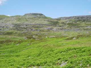 |
General view
The workings can be seen (more clearly in the enlargement) as the feature running from middle right and gently gaining height to left of the picture across the lower slopes of Foel Penolau. |
|
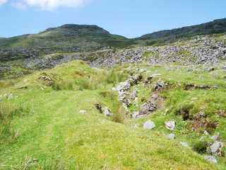 |
Workings
Open cut workings near SH66933461. |
|
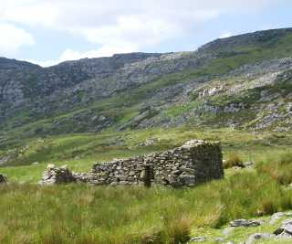 |
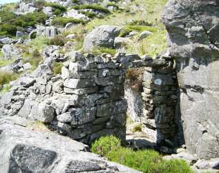
Building
Building at SH66863459. There is a window (partially walled-up) in the north wall opposite the doorway. This building pre-dates the workings (it is shown on the 1891 6" map [OS 1st edn: XIX NE]). It is possibly a hafoty, although it might have been used as a barracks when the mine was in operation. There is no hearth or chimney. |
|
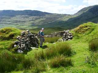 |
Tips
Overgrown stacked tips. The gap in which figure is standing appears to align with the building pictured above. These tips are presumed to be waste. (Are they what [Groves 1952] described as stacks of ore?) |
|
 |
Workings
Note finger tip to left of standing figure. |
|
 |
Shelter
Very small (1.5 m x 1m) shelter above workings at SH66663463 which would have accommodated two or perhaps three men at most sitting on the floor. The roof sloped from perhaps 1.5 m high at the door to .8 m opposite the door. Fragments of corrugated iron in the shelter suggest a corrugated iron roof. |