Cae Mab Seifion
| Alternative name |
Cae Mab Seifion North East [Wilkinson 2003] Cae Mab Seifion 2 (to distinguish it from Cae Mab Seifion 1 or East Clogau gold mine) |
||||||||||||||||
|---|---|---|---|---|---|---|---|---|---|---|---|---|---|---|---|---|---|
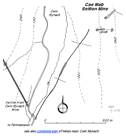
| Location | SH689217 (Area map showing location.) | ||||||||||||||||
| Parish | Llanelltyd | ||||||||||||||||
| Geology | The bed is .2–.25 m thick and consists of good quality ore [Dewey & Dines 1923: 69]. | ||||||||||||||||
| Owners | 1920–1921 William Horton | ||||||||||||||||
| Worked | 1921?–1923 [Gwyn 1998: app. 2: 155] | ||||||||||||||||
| Production and Employment |
|
||||||||||||||||
| Transport | Tramway from SH68872167 to loading wharf at SH68392086 on Cwm Mynach road. Road transport to Penmaen Pool railway station. | ||||||||||||||||
| Remains | Extensive workings about 90 m in length with tips and terraces of stacked waste along the bottom of low outcrop running uphill north-eastwards from SH68922172. In places the bed has been followed a short distance underground with walled-up waste used to support the overlying strata. The workings are overgrown with woodland. Possible tramway embankment or loading bank at SH68872167 with some bluestone waste. A masonry remnant along the line of the fence at SH68392086 where the tramway met the Cwm Mynach road may be the remains of the loading bank. In adition to these remains there is the level referred to by Down [1980: 46] and tip at SH68892167 and remains of a small building at SH68742141. (November 2006) | ||||||||||||||||
In May 1921 several hundred tons of ore were awaiting transport. A tramway was under construction between the valley road and the mine and the intention was to take the ore from the tramway loading bank to Penmaenpool station [Dewey & Dines 1923: 69]. The gauge of the tramway was 24" [Down 1980: 46].
It is not clear how the ore was transported from the workings to the tramway as this area has been severely affected by forestry plantation and subsequent clear-felling.
Down [1980: 46] identifies the manganese working with the level at SH68892167. However, exploration of this level shows it to be most probably a trial for minerals with no sign of manganese working. (It is probably associated with Cwm Mynach Isaf East mine [Wilkinson 2003].) Down’s plan [1980: 47] does not show the manganese workings mentioned above but shows two inclines connecting the tramway to the level. However, alternative interpretations of the site are that (a) only the lower incline existed with a remote drum or sheave house at the top of what Down shows as the upper incline or (b) what Down shows as inclines are run-in adit entrances, trial pits or natural hollows. Considering the lack of development in the level there would not seem to be any need for an incline at this location.
There are further mining remains in the form of a tip and a run-in adit (recently re-opened) at SH69002164, and a run-in level and building at SH69082166. These are further up the hillside from, and in line with, the above-mentioned level at SH68892167 and are probably what Wilkinson [2003] identifies as Cwm Mynach Isaf East mine. These and other levels shown on the 1887 6" map [OS 1st edn: XXXIII NW] near this location and at SH68672131 (Cwm Mynach Isaf South [Wilkinson 2003]) are marked as “Old Level (Manganese)”. However, all of these are probably associated with late 19th gold mining operations and the map legend is incorrect.
The 1985 1:25,000 map [OS 1985] shows the line of the tramway embankment. The 2000 1:25,000 map [OS 2000] shows the new forest road but omits the remaining portion of the tramway embankment. In March 2003 some traces of an embankment along the line of the tramway north of SH68632121 were visible. These have since been obscured by recent forestry clear-felling operations. South of this point to the site of the loading bank at SH68392086 the line of the tramway has been obsured by the forestry road.
Wilkinson [2003] lists a Cae Mab Seifion North East manganese mine at SH688208. However, this location is in the Gamlan Formation rather than the Hafotty and although there are mining remains at this location (a level at SH68682081 which goes for some distance to a dead end and a short trial at SH68862084) they do not appear to be manganese workings. Accordingly, it is considered that Cae Mab Seifion North East is an alternative name for Cae Mab Seifion manganese mine and the grid reference is incorrect.
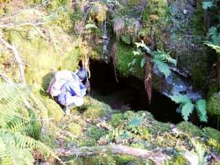 |
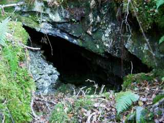
Workings
Entrance to workings. |
|
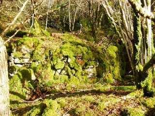 |
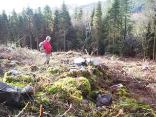
Stacked waste
One of the terraces of stacked waste. |
|
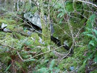 |
Workings
Open working along base of outcrop. |
|
 |
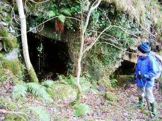
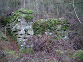
Workings
Entrance to workings. Note stacked waste to left of entrance. |
|
 |
Workings
Entrances to workings. The left-hand entrance leads into the worked bed running uphill behind the stacked waste (which supports the rock above) to another entrance on the next terrace above. |
|
 |
Embankment
Embankment or possibly loading bank for tramway at SH68872167. |
|
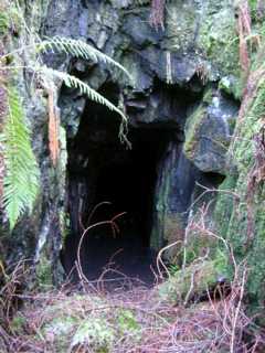 |
Level entrance
Entrance to level at SH68892167. This is the level that Down [1980: 46] identifies as Cae Mab Seifion manganese mine. It is approximately 2 m high by 1.5 m wide and runs straight for about 25 m to a dead end. There is about .9 m depth of standing water immediately inside the entrance. There is an iron bar projecting from the right hand side of the adit above water level perhaps 15 m from the entrance. There is no sign of development and the level is most probably a trial for minerals. |
|
 |
Building
Building remains, possibly a shelter, at SH68892167. Internal dimensions are aproximately 1.5 m wide x 3.1 m long. There is a low (.5 m high) wall (obscured by vegetation in the photograph) across part of the open side of the building facing the camera which runs from the right hand wall to leave an opening .6 m wide against the left hand wall. |