Bryn Mawr
| Location | SH805318 (Area map showing location.) |
|---|---|
| Parish | Llanuwchllyn |
| Owners | |
| Production and Employment | |
| Transport | |
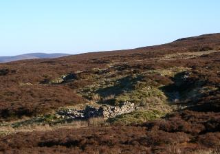
| Remains | Surface workings in the form of trenches and waste banks at SH80513184, SH80443185 and SH80443187. Roofless and delapidated building with pile of broken rock showing manganese mineralisation adjacent SH80353180. (February 2007) |
Probably an extensive trial. [Morris, Harold 2006, pers. comm.]
There is a pit in the ground at SH80383192 aproximately 1.5 m x 1.5 m x .5 m deep with a small sump of a further .3 m depth against a rock face in one corner of the pit which may be connected with this site (possibly a water source for the site).
The 1901 six-inch map [OS 2nd edn: XXI SW] does not show any indication of workings in this area so it is presumed that activity at this site was post-1901.